


Chasseradès - Finiels

JeanPierreNancy
User
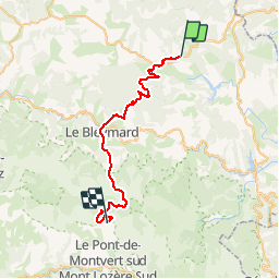

Length
38 km

Max alt
1609 m

Uphill gradient
1101 m
Km-Effort
52 km

Min alt
1063 m

Downhill gradient
1036 m
Boucle
No
Creation date :
2019-10-10 16:56:27.694
Updated on :
2019-10-10 16:57:34.186
3h22
Difficulty : Very difficult

FREE GPS app for hiking
 SityTrail
IGN / Geographical institutes
SityTrail Plus
The world is yours!
About
Trail Mountain bike of 38 km to be discovered at Occitania, Lozère, Mont Lozère et Goulet. This trail is proposed by JeanPierreNancy.
Positioning
Country:
France
Region :
Occitania
Department/Province :
Lozère
Municipality :
Mont Lozère et Goulet
Location:
Unknown
Start:(Dec)
Start:(UTM)
566563 ; 4933747 (31T) N.
Comments